
Archived information
Information identified as archived is provided for reference, research or recordkeeping purposes. It is not subject to the Government of Canada Web Standards and has not been altered or updated since it was archived. Please contact us to request a format other than those available.
Technical backgrounder - How it works: Article 76 of the United Nations Convention on the Law of the Sea
Article 76 of the United Nations Convention on the Law of the Sea combines scientific and legal concepts. It can be confusing to both scientists and lawyers since it gives scientific terms a legal meaning that is different from their usual scientific meaning.
This is a simplified explanation of a complex process and should not be taken as an exhaustive explanation.
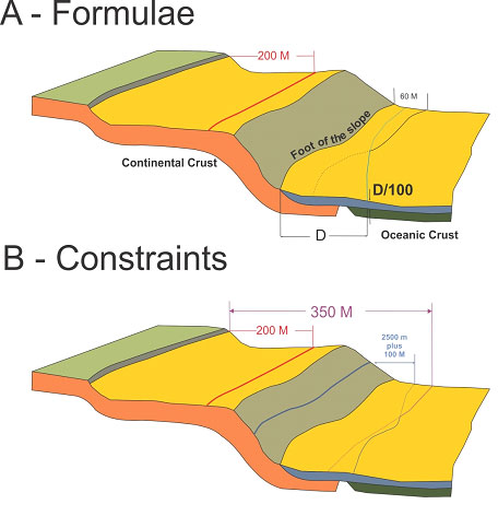
Under Article 76, the first thing a coastal state needs to do is locate the foot of the continental slope, which is usually where the maximum change in gradient occurs in a region called the base of the continental slope.
Then, the coastal state applies a combination of two formulas to determine how far out its shelf might go. These formulas are:
- measure 60 nautical miles (M) from the foot of the slope; and/or
- determine where the sediment thickness is at least one percent of the distance to the foot of the slope (i.e. depth ÷ distance ≥ 1 percent).
Next, the coastal state applies one of two constraints that curb the extent of the shelf. These are:
- 2,500-metre depth contour (also known as an isobath) plus 100 M; or
- 350 M from coastal baselines.
Note: This means that it is possible for the shelf to extend beyond 350 M.
Finally, the coastal state determines the outer limits of its continental shelf by following the formula line farthest from shore where the constraints are not exceeded and the constraint line farthest from shore where the formula lines exceed the constraint. Points on the formulae and constraint lines are joined by straight lines not exceeding 60 M in length. (See graphic, below.)
- Date modified: